
Hydrography#
hydrography loads river-network geometries. The network can be used for
overview maps, drainage interpretation, mesh constraints, and comparison with
simulated active networks.
Accepted sources#
Source |
Use when |
Source page |
|---|---|---|
|
A local river network is authoritative. |
|
|
The French BD Topage reference network is the intended public source. |
|
|
OpenStreetMap waterway geometries are sufficient or useful for broader screening. |
|
|
EU-Hydro coverage is the intended continental-scale reference. |
|
Minimal example#
[data]
types = ["hydrography"]

[[data.hydrography.sources]]
source = "bdtopage"
Loaded shape#
The loaded payload is a vector river network. Downstream checks usually focus on spatial alignment, network density, outlet consistency, and whether the network is suitable as a target for drainage or seepage diagnostics.
Visual check#

Provider-specific overlay#

Provider comparison#
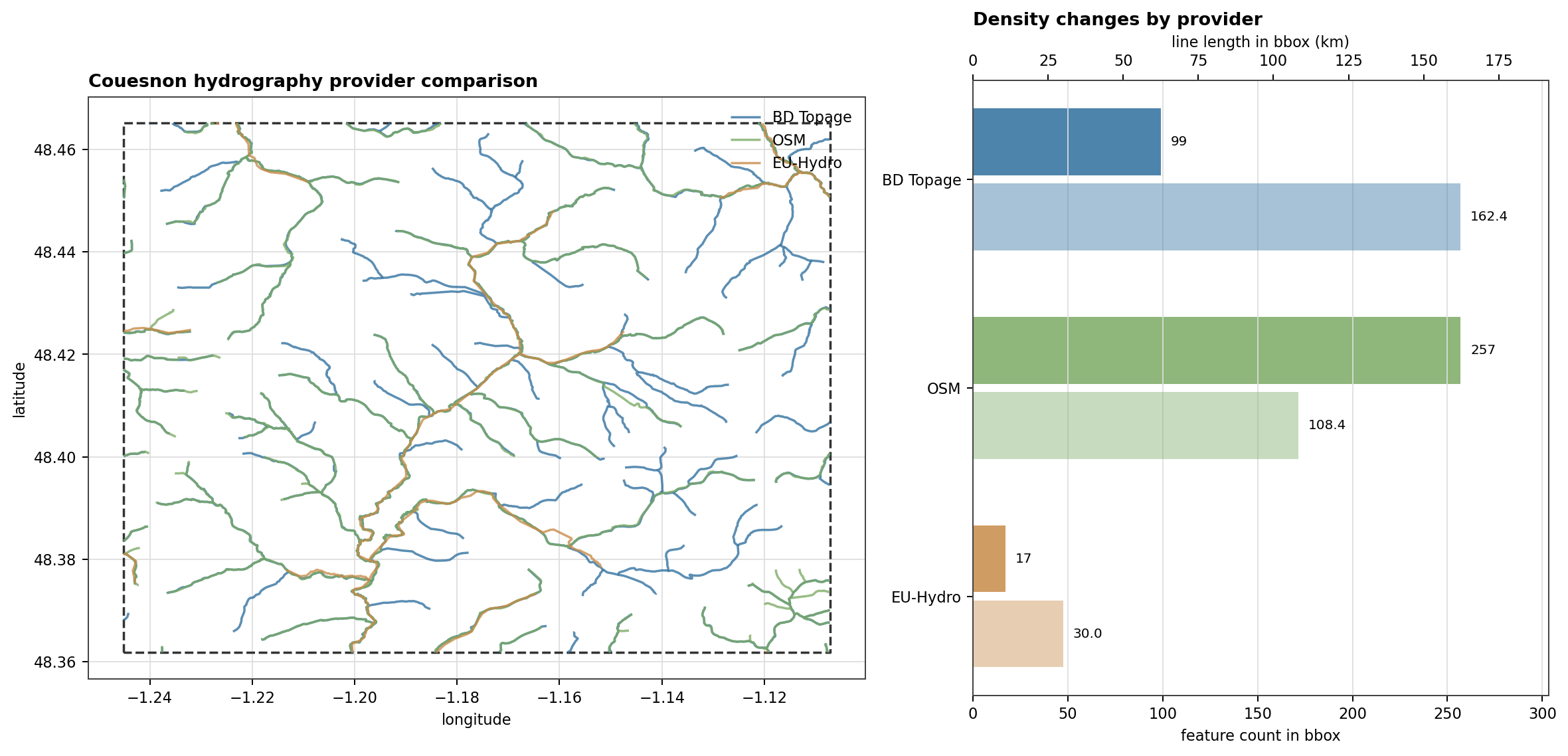
Fig. 146 When several public providers can load the same family, compare them before choosing one. The Couesnon replay makes the density and continuity differences visible without running a solver.#
Local spatial smoke test#
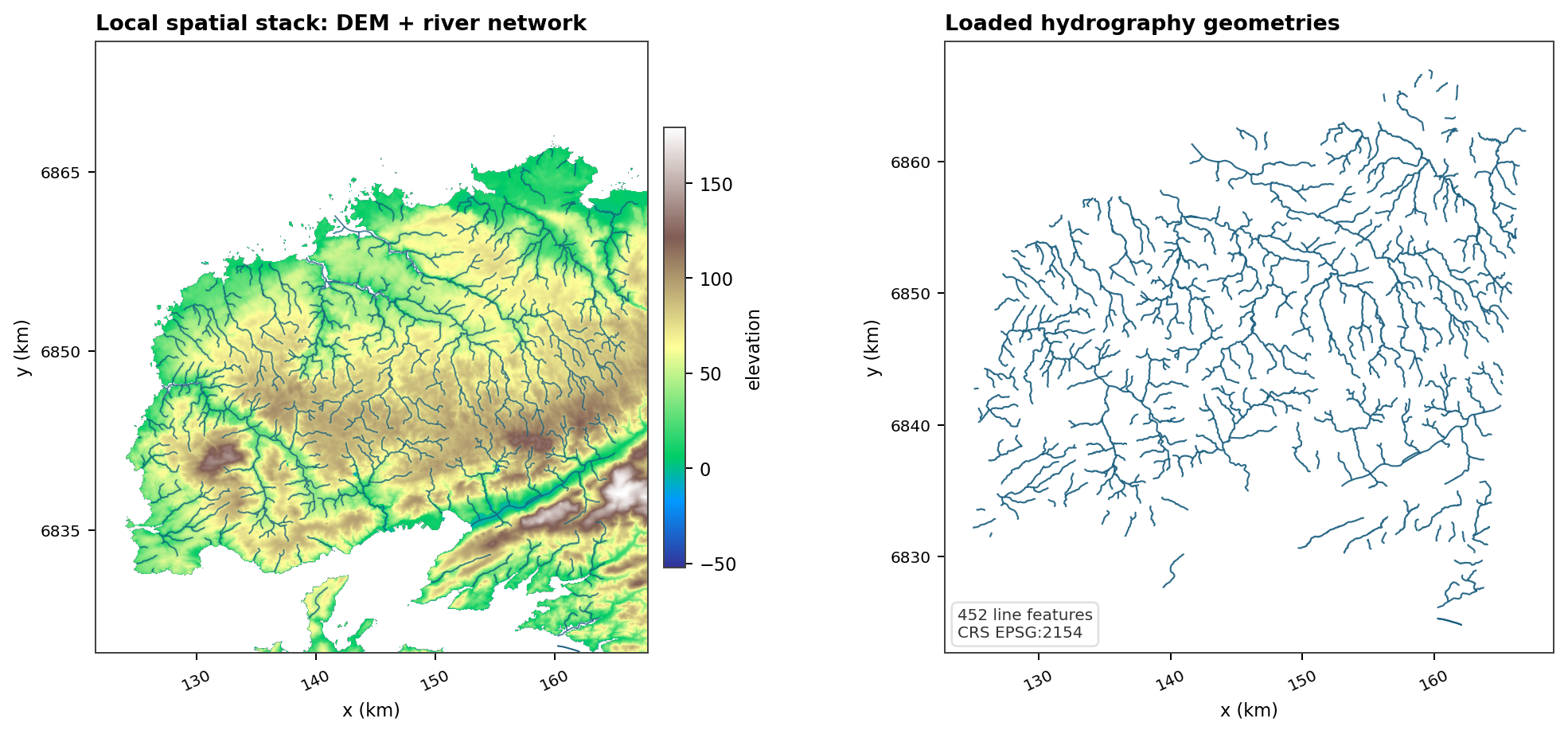
Fig. 147 The local data-doc run reads a versioned DEM and a versioned river-network vector. It is a compact check for CRS agreement, network density, and whether a custom hydrography file is spatially plausible before it is used for mesh constraints or active-network interpretation.#
Downstream uses#
hydrography panels in data overviews;
river constraints for meshes;
drainage target interpretation;
active-network comparison after simulation.
Hydrography Source: bdtopage#
Use source = "bdtopage" when the French BD Topage hydrographic network is
the expected reference.
Minimal example#
[[data.hydrography.sources]]
source = "bdtopage"
Operational checks#
Check network density against the intended drainage interpretation.
Check outlet alignment before comparing observed and simulated active networks.
Use a source-specific overlay when documenting that BD Topage itself is the provider under test.
Visual reference#
Provider replay#
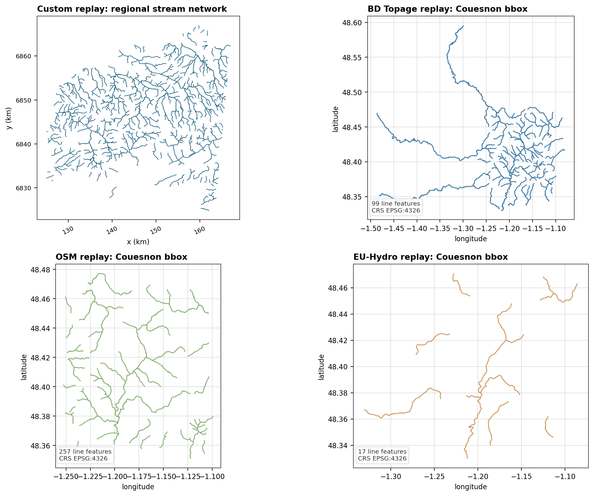
Fig. 149 The provider replay shows committed BD Topage samples separately from the broader local river network. This keeps the source under test readable before it is clipped, rasterized, or compared with simulated active networks.#
Provider comparison#
Fig. 150 In the Couesnon replay bbox, BD Topage provides an intermediate network density between OSM and EU-Hydro. This is the kind of first-order provider effect that should be visible before a network is used as a meshing or drainage reference.#
Hydrography Source: custom#
Use source = "custom" when a local river-network layer should be trusted
over public providers.
Minimal example#
[[data.hydrography.sources]]
source = "custom"
path = "data/hydrography/rivers.gpkg"
rasterize_field = "FID"
Operational checks#
The network CRS must match or be safely reprojectable to the project CRS.
The layer should cover the modeled basin and its outlet neighborhood.
rasterize_fieldshould identify stable features when raster products are generated.A correct file path is not enough; inspect the map overlay.
Hydrography Source: euhydro#
Use source = "euhydro" when EU-Hydro coverage is the intended
continental-scale river-network reference.
Minimal example#
[[data.hydrography.sources]]
source = "euhydro"
Operational checks#
Check that the selected extent is large enough to retrieve the expected network around the basin.
Compare network density with the modeling scale; continental products may be too coarse for small headwater studies.
Inspect the river overlay before using the network as a mesh or drainage target.
Provider replay#
Fig. 151 The replay figure includes a committed EU-Hydro GPKG on the Couesnon bbox. This keeps the provider visible in the documentation while making clear that it is coarser than local or national hydrography on small headwater windows.#
Provider comparison#
Fig. 152 EU-Hydro retrieves fewer line features on this bbox. That is useful evidence: continental coverage is not automatically the right support for a small basin, and the comparison should be inspected before selecting it as a network reference.#
Hydrography Source: osm#
Use source = "osm" when OpenStreetMap waterway geometries are acceptable
for screening, teaching, or projects where a public local reference is not
available.
Minimal example#
[[data.hydrography.sources]]
source = "osm"
waterway_types = ["river", "stream"]
Operational checks#
waterway_typescontrols which OSM waterway classes are retained.OSM completeness can vary by region, so visual inspection is mandatory.
Avoid treating OSM density as a hydrological truth without local validation.
Provider replay#
Fig. 153 The replay figure includes a committed OSM GPKG on the Couesnon bbox. It should be read as a provider payload check, not as proof that OSM is always complete enough for modeling.#
Provider comparison#
Fig. 154 On this bbox, OSM contributes the densest small-stream network. That can be valuable for screening, but it also reinforces why OSM needs visual validation against local knowledge or an institutional reference before it becomes a modeling constraint.#